 On Friday, Oct. 17th, 2008 I headed up to Lanesborough, MA to hike around in the Mt. Greylock State Reservation area. The AT runs through this reservation and over the summit of Mt. Greylock, the highest point in Massachusetts at 3491 feet. I wanted to get some miles in on The Trail, and had invited a friend of mine to come along. Well, I wound up going alone. Click here for more info on Mt. Greylock Reservation.
The drive from Plymouth to Lanesborough was about 2 hrs, 15 mins. I got a bit of a late start, due to some last minute errands I needed to run. When I arrived at the Visitor's Center at about 4 pm, I spoke with one of the rangers up there about the reservation and the AT. He told me the closest shelter to the VC was the Mark Noepel shelter, 6 miles away. So, that's where I headed. It was getting late, just about 4:40 pm when I finally hit the trail.
From the VC I headed north, taking the Northrup Trail to Jones Nose, which then intersects the AT just below Saddle Ball Mountain. From that point, I turned southeast on the AT for less than a mile before I reached the shelter. It started getting dark a little after 6 pm, which didn't worry me, as I did bring my headlamp for such occasions. Around 6:40, I finally decided to pull out the headlamp. Now, I did test all my equipment, especially the headlamp back at home before leaving to come up here. But, wouldn't ya know it, when I took it out and pressed the button, nothing happened. Luckily for me, I had a small photon light in my pocket. That little thing got me through the darkness and to the shelter.
Once at the shelter, I looked around, found some old batteries. After a couple minutes, I was able to get my headlamp working. That was a relief! Seeing now was much better than with the photon light I was using. There was a bunch of branches and limbs gathered near the firepit by previous hikers or rangers, and a saw inside the shelter for cutting up the thicker stuff. So I built a fire, which took a while to get burning well with the wind that was kicking up. Inside the shelter, I changed into some warmer clothes and even set up my tent. I figured since I was the only one there, the wind beginning to blow, I may be a bit warmer this way.
The old faithful shelter register was in a box on a wall inside the shelter. I thumbed through it, recognized several names on its pages. It took me back in my mind not too many months ago, and I envisioned myself writing an entry. I was tired & hungry, but skipped dinner to get inside my bag and sleep. It wasn't a good night's sleep, as several animals were heard around the shelter. Something, a bobcat I suspect, was beneath the shelter, growling at something else. I don't know how cold it got that night, but it felt about 20 degrees.
In the morning, as usual, I tossed & turned in my bag, delaying the inevitable. But this time, I was really hungry, having skipped dinner the night before. So, I cooked up some Ramen noodles & a tuna packet, had 2 cups of coffee, and I was ready for the privy! It was about 9:30 when I eventually hit the trail. Greylock summit was a little over 3 miles from the shelter, and my goal was to reach it by noon, so I was in no real hurry to get going. Besides, out here all you have is time, and I was enjoying every minute on the trail. On the way to the summit, I took lots of pictures. Unfortunately, as I write this entry, I don't seem to have them all saved in my computer. I'm not quite sure what happened to most of them. There was one of a tree with some claw markings from a black bear. That was pretty cool, but now it's gone I guess.
When I reached the summit, it was just about 11:30 am, bright & sunny. There were a few other hikers, some runners that passed me on their way down the mountain. I drank some water & had a snack. My water was getting low, and I was contemplating how much further I'd go. The original plan was to hike all day and camp overnight again, then get up Sunday morning and head back to the VC. But that was if my friend Bob came along with me, which he didn't. So I decided that I'd hike back to the VC, another 8 miles away. I spoke with another hiker who was out doing a small section of the AT this weekend. He also was hiking alone, as a friend of his stuck him, too. I walked around the Massachusetts Veterans War Memorial, read the inscriptions on its impressive structure. The view behind the Memorial is fantastic, stretching into New Hampshire's White Mountains. Some of the pics I took from this spot are seemingly lost.
  Bascom Lodge is also nearby, and like the War Memorial, is open seasonally. Because the Scenic Byway was closed for construction, not re-opening till Spring of 2009, the summit was pretty desolate. Normally, the weekend brings scores of people up here. I wasn't aware of the construction going on in this area until a few days before I headed up here, and didn't even think of encountering any crowds on the summit. But it was enjoyable just to sit in the sun and relax for a bit before heading back down.
 Those mountains in the distance are what every thru-hiker has travelled towards and climbed. I thought of all the fine people I met along the trail last spring, the happiness of their thru-hike, and what it is they're doing now. I look forward to seeing some of them again, and to meeting new people this coming spring.
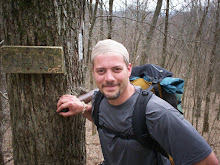
 This here is one last look before heading back down to the Visitor's Center. I reached the VC a little after 4 pm that day, hiking a total of 17.3 miles on my mini get-away. It was a needed time away alone, even if just for a day and a half. Anyone who loves to hike knows just what I'm talking about, especially that which can't seem to be put into words. "What do you do when you go hiking?" people ask me sometimes. "Well, I hike. I enjoy the scenery, take pictures, make memories, think deep thoughts," lol.
~The Pilgrim.


Lonely Planet – Where To Go When: Hiking
11 hours ago

0 comments:
Post a Comment