Monday, June 22, 2009

Crude Analysiz Moved To Wordpress

After several months of posting here, I've decided to move the blog to a hosted account, using Wordpress as the blogging platform. For all who've enjoyed reading the Crude Analysiz Blog, thank you for your support, & I hope you'll continue to follow along in our hiking stories & gear reviews.

Please follow along at www.crudeanalysiz.com

~The Pilgrim.

Wednesday, June 10, 2009

Franconia Ridge Memorial Day '09

On Friday, May 22nd, I headed up to Franconia Notch State Park with my sweetheart, Beth, her sister & her boyfriend. Of course, my buddy Skippy Bones 100_0569 also came along for the hike. Skippy is a lean, mean hikin' machine. Many of the hikers we met over the weekend were impressed with his ability & stamina in hiking. In fact, I think Skip hiked 3x the distance we did. He'd run up the trail ahead of us, wait a few seconds, then turn & run back down to get us. The plan was to hike three days & camp two nights, and Bones was just as excited as we were!

We took one car & drove up I-93 to NH, parked at the Lafayette Campground on the east side of 93. We figured on hiking up the Old Bridle Path towards Greenleaf Hut. It was chilly when we started out, and started later than we'd planned. But we pushed up the trail at a brisk pace. The views were fantastic as we drew closer to the hut. 100_0550

At the top of the climb where the hut rests the wind was really blowing good. On the way up I wore a long sleeve top & shorts. After a couple of minutes, I walked into the hut & talked a bit with one of the young guys working in the kitchen, asked him about a spot for us to camp for the night. He said there was a little clearing down the Greenleaf Trail a bit.

100_0555 The huts up here are pretty basic, small houses with bunk beds, plywood walls, a full kitchen & an indoor bathroom. I wouldn't mind staying here if it wasn't for the price. For non AMC members, I think it's $86 a night. It includes dinner & breakfast. Beth & I are members of the AMC, but the price was still $77 or something like that. I went back outside, pulled out my rain jacket/wind breaker and sat down with Skippy to wait for the others coming up behind.

There's no camping within 1/4 mile of the huts in NH. There are signs marking the radius on the trails surrounding the huts. We hiked west down the Greenleaf Trail as the young guy at the hut had suggested. The trail is lined with rocks, easy to turn an ankle or trip. It wasn't long after we passed the 1/4 mile marker that Beth found a clearing to the left. The area is heavily wooded, but as we headed toward the clearing, we noticed several nice spots to set up a tent. It was getting late, we were all tired. The girls started dinner while Anthony & I set up the tents. Skippy explored the tent site.

100_0558

It was chilly again on Sat morning, but not too bad. Our agenda, after breakfast of course, was to head back up Greenleaf Trail past the hut & up to Franconia Ridge/AT. It was good hiking, chilly but good. Lots of people were out this weekend for Memorial Day, and I think if the weather was a bit nicer, it would've been much busier.

There were 30-40 people up on Mount Lafayette when we reached the top. Lots of talking, eating, people asking how Skippy was doing on the trail, if100_0561 we needed to carry him up the mountain at all. My reply was, "are you kiddin'? He's the only one NOT panting." 

All the way up Mount Lafayette I was thinking & looking forward to a beautiful 360 degree view of the la100_0565ndscape. It didn't disappoint. It's beautiful up here, and I'm looking forward to coming back in the summer when I return to the AT. My five week stint on the AT last year seems like yesterday, but at  the same time, so long ago. Backpacking is a time to get away from the busyness of everyday life, to think & look at life from a different perspective. Problems back home seem so small out here, like pebbles to mountains.

We headed south on the AT from the top of Lafayette. Over Lincoln & Little Haystack we passed, hiking beyond the junction of Falling Waters Trail. The AMC Liberty Spring Tentsite was less than 2 miles from the top of Little Haystack, but our intention was to set up100_0564 camp somewhere in between the mountaintop & the tentsite. We found a good spot, even better than the night before, about 1/4 mile beyond the junction of Falling Waters Trail. We had a good fire that night, sat & talked, drank some wine. Dinner was chicken, rice & red beans. We climbed into our tents a little after 9 pm.

Late Sat night a storm swept through; wind, rain, thunder & lightning. The tents held up fine, though sleep was off & on because of all the noise. Our thoughts were on the climb back up the mountain to reach the Falling Waters Trail. There were some good size boulders we encountered on the descent. Things always seem a bit worse when you're tired.

100_0571The climb back up over the boulders wasn't too bad. In fact, we reached the junction of Falling Waters Trail 15 mins after leaving camp. It was cold & rainy at the top, but the forecast that day for the park region below called for sun & temps in the mid-70s. We were looking forward to getting down.

Falling Waters Trail was everything I'd heard it was, beautiful waterfalls & gorgeous scenery. At one point we lost the trail, going beyond the trail marker. I think we didn't see it because we were too interested in the sloping rocks before us. After we realized that there was nowhere to go but into a pool of water, we turned back up the rocks & found the marker, then continued back on the trail. The detour took about 10 minutes of our time. The lower we descended, the sunnier & warmer it felt, and the park was crowded with hikers. We reached the parking lot around 2 pm. As Slightly would say, "Good Times."

~The Pilgrim.

Thursday, May 14, 2009

Food Vendors At Fenway Park

This past Sunday, May 10th, my lovely woman & I went into Boston to watch the Red Sox play the Tampa Bay Rred_sox1ays at Fenway Park. I have to be honest, every time I get set to go into Boston, I dread the people, the noise, whether it's driving or taking the train, walking or whatever. Part of me doesn't want to go through it. But when I get there, I'm always glad to be in Fenway Park!

We took the train in from Wollaston, on the way discussing the weather & what we'd eat once we were inside the Park. A Fenway Frank was at the top of the list, of course! I think it wasn't until the end of the fifth inning when we went to go get some food. Standing in line at one of the hotdog stands, my sweetheart says to me, "Honey, look at the guy in the back, look at what he's doing." When I first caught sight of the young guy, in the back of the work area within the stand itself, I wasn't sure if what I was seeing was what I thought I was seeing.

This young guy, standing behind one of the food preparation counters, was taking the foil bags, those which hold your hotdog after it's placed in the bun; you know those foil bags? One at a time, he'd pick one up, open it & place it on a tray where one of the other employees could take it & throw a hotdog in. Well, in his bright, young mind, he figured he could speed up the process of opening the bags by blowing into them. Yes, that's right, he was blowing air, with his mouth, into each of the foil bags!

My sweetheart walked over to the side of the stand, calling to another employee. She then explained to them how the guy in the back was blowing into the foil bags as he was opening them. There were at least three other employees working the stand who, when hearing of the bright activity of their teammate, turned & looked at him in amazement. One of the girls asked him clearly, "Were you really doing that?" His response was to hold his hands in an outward gesture, as if to say, "What?"

I called back to him, "You don't understand, do you?" Once again, he held out his hands to his sides, a look of "what's the big deal?" on his face. "You're wearing plastic gloves on your hands and you're blowing into the bags. Kind of defeats the purpose of germ prevention." He didn't understand, and I don't mean he didn't understand english. He didn't understand what the big deal was about blowing into the bags.

It's commonly known that when you blow onto or into something you are, in essence, spitting onto or into that something. Tiny particles of saliva are leaving your mouth, each filled with little germ passengers, to spread their message of sickness & bacteria to others. This is how viruses & common colds are passed around. This is how the dreaded Human Swine Flu is contracted. It's unbelievable to me how this young food vendor would even think of doing something as irresponsible as blowing into or onto anything within a food establishment!

Now, I'm not saying this kid is passing around the Swine Flu or any flu for that matter. But he's not thinking about what he's doing, and that could be because he's not being educated properly in how he should handle himself within his job environment. Maybe there should be some stricter regulations on the food vendors within all ballparks, not just at Fenway Park. I love Fenway Park & I love the Red Sox! I love the Fenway Franks & giant pretzels. But I love my health much more, and think that maybe someone should look into this.

~The Pilgrim.

Thursday, May 7, 2009

Steve Gillman's Hiking & Backpacking Articles

If you've been an ultralight hiker for any great length of time, then you've probably heard of a guy by the name of Steve Gillman. If you haven't, then go and check out http://www.the-ultralight-site.com/. Steve has posted countless articles on the subjects of hiking & backpacking, wilderness tips & some other subjects as well.

Most everyone in the backpacking community knows of Ray Jardine, commonly known as the father of ultralight backpacking. Ray's revolutionary ideas & views on hiking with lighter weight has literally transformed the way thousands of people all over the world enjoy the outdoor world today. His site, http://www.rayjardine.com/, is packed full of tips & kits for sale, everything from making your own pack to tarp-tent, backpack to knife-making kit. Lots of good stuff at reasonable prices.

Steve Gillman has done much to further educate hikers & backpackers in the area of ultralight hiking. His latest article on building a wilderness shelter can be seen at http://ezinearticles.com/?id=2298274. It's a really good article. His book, Ultralight Backpacking Secrets, can be downloaded through his site for $7. The information found in his book is well worth more than the $7 charge.

I've implented quite a few of the suggestions from Steve's book, as well as other articles of his. So, for anyone looking to gain a bit of knowledge & more insight into ultralight hiking, head on over to Steve's site & check it out.

~Till next time, The Pilgrim.

Wednesday, April 29, 2009

Whitney & Thayer Woods

100_0328 There's a place in Cohasset, MA off of route 3a where I love to go with my Sweetheart Beth & my dog Skippy for a walk & short hike. It's called Whitney & Thayer Woods. Not being real close to any real mountains where I live, this place still provides a good way to enjoy nature & stretch the leg muscles some.

Whitney & Thayer Woods is one of 95 properties owned by The Trustees Of Reservations in MA, comprised of more than 800 acres and over 10 miles of trails within its boundaries. Many of the paths & trails are named after early benefactors of the organization, such as Milliken Memorial Path. In the late 1920s Arthur N. Milliken planted many flowering shrubs as a memorial to his wife, Mabel Minott Milliken. Rhododendrons still bloom here each spring. A grouping of glacial erratics mark certain areas of the landscape, such as Ode's Den. This was named after Theodore "Ode" Pritchard who, after losing his home in 1830, lived under one of the boulders. Bigelow Boulder was named in honor of the late author of the first volume of The Narrative History Of Cohasset.


The Trustees Of Reservations website gives a good synopsis of this beautiful landscape. Here's an excerpt from the website:


Much of Whitney & Thayer Woods was originally the "Common Lands of the Hingham Planters," referring to the colonists who settled the area beginning around 1634. Around 1904, Henry M. Whitney began purchasing parcels of abandoned farmland to create a private estate. The Whitney Woods Association later acquired much of the estate and donated more than 600 acres to The Trustees Of Reservations in 1933. Ten years later, Thayer Woods was also donated, and the Reservation became known as Whitney & Thayer Woods.


The property sits adjacent to another piece of land also owned by the The Trustees, 62 acre Turkey Hill. This area is co-managed by the towns of Cohasset & Hingham and is situated close to Weir Farm. Sitting atop the 187 ft summit of Turkey Hill is the remains of an anti-missile radar control station, built at the time of the cold war & used to help thwart potential nuclear attacks by the then known Soviet Union. It's a basic cinder block structure, now stripped & empty of any equipment it once housed.


These two properties make for a great day hike, and if100_0332_00 starting from Whitney Woods, you can incorporate a picnic atop Turkey Hill in the spring & summer months. There are several paths within Whitney & Thayer Woods which pass through heavily wooded areas, as well as old carts paths outlining the perimeter of the property. The terrain varies with ups & downs, rocky outcrops & wooden bridges crossing streams & wet areas. The wider paths are used by mountain bikers & runners on a daily basis. During the winter months, the trails are used for both cross-country skiing & snowshoeing.


100_0327_00


A walk around the property at Whitney & Thayer Woods is roughly 2-3 hours. There are bulletin boards providing printed trail maps in designated parking areas, and you can even download a copy from http://www.thetrustees.org/pages/21_trail_map_library.cfm. Many of the secondary trails within the property's confines aren't marked on the map, though markers are placed throughout along the trails & paths. It's possible that some trails or markers are mis-marked, as a couple spots on the map don't agree with the physical terrain. This is been a discussion between Beth & I more than once.


On The Trustees Of Reservations website is listed that interpretive tours & programs are offered during the year. I've never signed up for one, nor do I know anyone who has. If you want more information on this, check out their website.


Here's some other links below with information regarding Whitney & Thayer Woods:


http://www.thetrustees.org/pages/392_whitney_and_thayer_woods.cfm


http://www.thetrustees.org/pages/21_trail_map_library.cfm

Tuesday, April 28, 2009

Book Review Of Epic: Stories Of Survival... by Clint Willis

If you enjoy survival & adventure stories like I do, then Epic:  Stories Of Survival From The World's Highest Peaks should keep you entertained for several nights. This book is a collection of stories from climbers who faced unbelievable circumstances while climbing Everest, K2, Anna Purna and other dangerous mountains.


Each chapter features individual accounts from men such as John Krakauer, Greg Child, Joe Tasker, Peter Boardman, David Roberts, Eric Shipton & Alfred Lansing, as well as many more. Some of the conditions these men faced were extreme, even the worst possible scenarios one could imagine. As I read this collection by Clint Willis, I imagined myself in these particular situations, and tried to visualize just how I'd be able to cope as well as some of these men did. I found myself in one instant believing how crazy they were, yet simultaneously feeling how awesome to survive against such overwhelming odds.

Each time I've found myself in a book discussion with friends or people in general, this book is one I mention quite frequently. Clint Willis has also put out some other collections of mountain rescue expeditions. No doubt I'll be picking up some more of his books. Grab yourself a copy & enjoy!

~The Pilgrim.

Monday, April 27, 2009

Gear Reviews: Granite Gear Virga, Pack Pocket & Belt Pocket

Alright, it's long overdue...my backpack system that I used for my Spring '08 AT Section Hike, and my review. First off, let me say that I tried to keep it all pretty lightweight, though at the beginning of my hike the weight was more than I'd planned it being. As the weeks passed, I modified my methods & shed some pounds. Pack weight with food & water at the start was roughly 35 lbs. The last week it was just under 25 lbs.

Granite Gear Men's Virga Ultralight Pack (Spring 2009)

My pack was a Granite Gear Virga Ultralight Pack. It's a frameless pack, meaning that it has no internal stays to support the pack. When it's empty, it crumbles like an empty duffel bag. This is the nature of frameless packs, designed to be shored up by using a foam sleeping bag inserted inside the pack's main compartment. It has a roll-top design with 2 side pockets made of neoprene. The load-lifter straps do a great job keeping the pack tight to the back, and the simple nylon waist belt was comfortable for me. Some people prefer the thicker padded belts as featured on many ultralight packs today, such as on the Vapor Trail pictured below. The Virga is a lighter pack, though, a bit more stripped down.

Granite Gear Men's Vapor Trail Ultralight Pack (Spring 2009)

Weighing in at 1 lb 3 oz, the Virga is slated to carry a load of up to 20 lbs comfortably. When I had 35 lbs filling the 3200 cubic-inch capacity, I could feel it. So when I finally got the weight down, this pack was as advertised. It was comfortable, and durability-wise, this pack is very tough. I love the Granite Gear Virga & recommend it to anyone looking for an ultralight pack with basic but important features.

Attached to one side of my pack was a medium-sized Pack Pocket from Granite Gear. The Pack Pocket is attached to your pack by the side compression straps. Great for adding just a little more room to your pack. I had my plastic hole-digger stashed inside, along with tp, wet wipes & my low-cut gaiters. This Pocket will work with many other pack designs which have 2 side compression straps. This is something I highly recommend if you need a place to stash some quick-access items.

Granite Gear Pack Pocket (Spring 2009)

On the waist belt of my pack was the Belt Pocket, also from Granite Gear. I met several hikers who also carried one of these, holding everything from energy bars to cameras & cell phones. Another great item to add to your pack. They come in a left & right version, and I did see a couple of hikers who had both left & right Belt Pockets. Mine was the right hand version. I will say that I needed to do some modifying to my Virga Pack in order to securely attach this thing. It was some simple stitching and not a problem for me, being the son of a seamstress. The Belt Pocket does fit easily onto the thicker padded belt of the Vapor Trail, as well as other brand name packs.

Granite Gear Belt Pocket (Fall 2008)

Well, there you have my backpack system, which totaled barely over 2 lbs. Although there were some others who's pack weight was lower than mine, still I had some envious hikers of me when I answered their question of my pack weight. When I return to the AT, there'll be some changes to how I pack my gear, as I'm always tinkering & fiddling with things. It's a system that works for me, and hopefully this has given some of you a few ideas. So, get some gear & get out there!

~The Pilgrim.

Saturday, April 18, 2009

Ultralight Means Practical

Ray Jardine is most commonly referred to as the father of ultralight backpacking. His contributions to hiking, backpacking, camping, kayaking & other venues of outdoor activities have been limitless. For decades, Ray & his wife Jenny have tirelessly explored the world, building their own gear & constantly seeking ways to improve upon their own ideas. If you've never visited their site, check it out at http://www.rayjardine.com/index.shtml .

Steve Gillman is another outdoor enthusiast who's done much in promoting ultralight hiking. Steve gives a lot of great ideas, many of which I've incorporated into my own hiking & backpacking lifestyle. His site, http://www.the-ultralight-site.com/ has been a resource for thousands of hikers & wilderness students for several years. He runs the gamut with countless ideas regarding ways to shed grams & save weight, not all of which he practices himself. Of all the articles and info I've read by Mr. Gillman, one thing that impresses me is how practical he is. It's one thing to cut weight from your pack, but to go as far as some people go, I feel borders on absurdity.

Ultralight hiking & backpacking isn't just about going "light & fast," a slogan which I feel is mis-leading & not truly indicative of what the ultralight philosophy is. UL hiking isn't just about going as fast as you can. You want to enjoy where you're going & what you're going through, right? UL backpacking isn't simply about cutting as much weight out of your pack as you possibly can, but also in being a practical hiker & common sense backpacker.

It cracks me up sometimes when I hear of extremes that some hikers go to to shave a few grams off their pack weight. Things that go a bit further than cutting your toothbrush in half. I won't go into details here, but I'm sure if you've been around long enough & have dropped in on some hiking forums, you've heard or read some pretty funny things. Some of the things you'll see & hear are that which hikers make up & poke fun at, joking at their own expense. It can be entertaining. One thing every hiker or backpacker needs at all times is a knife. It doesn't need to be a Bowie, but you should have some type of knife. In my pants pocket everyday I carry a Mini-Paraframe by Gerber. There's seldom a day that I don't use it.

UL backpacking is a philosophy which I subscribe to, but not to an extreme degree. My goal here isn't to give a list of ways to cut your pack weight, as Steve Gillman has covered this in depth in his writings. Yet I'll just give some observations concerning UL hiking & backpacking.

  1. Buy reusable equipment. This may sound odd, but in this day of instant this & disposable that, it makes more sense that if one is concerned with going ultralight, they'll invest in equipment that's durable and dependable. This is more practical and in the long run, saves money. I read in a forum where a hiker was looking forward to getting some throw-away toothbrushes, where you get one use from one toothbrush. Huh? Disposable toothbrush, come on now! How practical is that? What a waste of money & time. Not only that, but how can you actually believe you're shedding weight by having to buy several of these things if you're going on a mulit-day hike? UL here means ultra-lame!
  2. When thinking of cutting weight, first think of what you want to carry. We don't usually have too much problem thinking of all the things we'd like to have with us when away from home.
  3. Next, think of what you should carry. This narrows down your list quite a bit. Of course we all bring an item or two that may not really be needed on a hike. That's our choice, and allowing yourself a small luxury in some cases is a good idea.
  4. Decide what you will carry. Sounds simple, but far too many of us have items in our packs that we bring along just because we're not sure if we should. When in doubt, do without.
  5. Focus & be concerned with what you carry, not what others are carrying. Stop telling others that they shouldn't be packing something just because you're not. If they ask for your opinion, that's one thing. But too many hikers feel that they have the authority to pick on other hikers.
  6. This is another should be no-brainer. Hiking your own hike doesn't mean that you're way of hiking is the only right way and everyone else's is wrong. If you're not carrying an mp3 player, fine, but don't expect everyone else shouldn't either. Hike your own hike doesn't mean "you hike the way I hike." 

Last year hiking the AT I met a lot of good people. Some folks I'd love to see again, some others well, you get the idea. I learned some things from both groups of people. I learned that UL is a relevant term, that it's translated in various ways. What works for one doesn't for another. What helps one is a hindrance to another. Hike your own hike, be a practical hiker & common sense backpacker. Be resourceful & take care of your equipment. Respect your fellow hikers & always be ready to help. And of course, always carry a knife. smile_wink

Thanks for reading,

~The Pilgrim.

Wednesday, April 15, 2009

Riga Shelter Salisbury, CT

On April 11th my sweetheart & I drove down to Salisbury, CT for an overnight stay on the Appalachian Trail. Most of the drive there it rained, but as we approached Connecticut, the skies were growing more & more clearer. The forecast called for rain early Saturday, clearing in the afternoon and night, then sunny and 55 degrees for Sunday. We were looking forward to a good weekend hike.

We arrived at the parking lot on Rte 41 which leads to the Undermountain Trail around 4:30 pm. We headed up the trail to the point where it forks to the left with the junction of the Paradise Lane Trail. This lead another half a mile or so until we reached the AT. Turning south on the AT, we stopped a half mile up the trail at the Brassie Brook Shelter for a few minutes, grabbed a snack before heading on to the Riga Shelter, another 1.8 miles away.

100_0299_00 It was overcast & cool on our way to Riga, the trail clear & pretty easy going. The trail crossed over a stream a number of times and we enjoyed rock-hopping & crossing the small bridges when available. The cool breeze and lateness of the day told us we were in for a cold night.

Another hiker was already in the Riga Shelter when we finally reached it; we think his name was Larry, after looking through the shelter register the next morning. He told us he'd been there since Friday night around 9 pm, and that it had rained Saturday until about 1 in the afternoon. So he waited out the rain, reading, and stayed through until Sunday morning.

Riga Shelter sleeps 6 like Brassie Brook, but for some reason, appeared a little smaller than the other shelter. But one of the first things I noticed was the new steps leading up to the shelter, built by the trail maintainers. Larry said they had dropped in 8 loads of lumber by helicopter, enough to build the steps, a new privy & two new tent platforms. They did a great job! My hat's off to all who give of their time & energy in helping to maintain what so many of us take for granted. In the near future, I want to start doing my part in volunteering when I can.

We decided to set up100_0305_00 our tent on the platform directly behind the shelter, about 30 yards away. Beth is a cold sleeper, so I figured it'd be warmer in the tent rather than the shelter. Larry probably enjoyed his privacy, too. Beth cooked our meal of rice & beans with some white chicken while I set up the tent. Some hot tea helped keep us warm till we turned in for the night. There was a wash pit about 10 yards from our tent that we used to clean up. The stream running close by was a relaxing sound as we fell asleep.

100_0310_00 Easter Sunday greeted us with a nice sunrise! Though it was still chilly, we were looking forward to a 55 degree day, or so it was forecasted. Little did we know, it would turn out to be mid-40s at best. But it was sunny, so we still had an enjoyable hike. 100_0312_00

The shelter was empty when we woke, so Larry must've got an early start. We set up the stove near the shelter to warm up some tea & had a light breakfast. We eventually got back on the trail at 9:48 am.

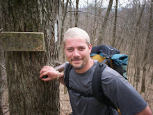
Crisp, cool days always get me moving a bit quicker than hot days, and I enjoy hiking in this weather. The climb up the south side of Bear Mountain wasn't too strenuous, and a bit more taxing for the last 100 yards or so. We had a great view once we reached the summit, climbed up on the remaining rocks of the once standing tower. 

The wind was blowing pretty well, so we didn't stay on top of the tower for long, just long en100_0318_00ough to say  we did & snapped a few pictures.   I was thinking of our trip down the north side of the mountain, as I'd read in an online forum a few days before that there were still many downed trees blocking parts of the trail. 100_0317 The trail maintainers have done a great job in clearing out most of the debris left behind from the ice storms this past winter. It's still pretty early in the season, and I'm sure they'll have the remainder of the stuff cleared away very soon.

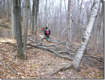
Everything I'd read of hiking the north side of Bear Mountain was pretty accurate. It was real steep in some spots and going was slow, but lots of fun. I can only imagine how tough it was with snow & ice covering the rocks. In some spots we saw marks left from crampons on the rocks, long scraping lines. 100_0320_00

100_0323_00

In several spots along the trail we needed to go around the fallen trees. Most of the damage was found along the north face of the mountain and the base. As we hiked further north, there didn't seem to be as much debris.

100_0326

100_0322

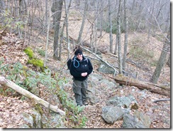
Hiking solo for me is very enjoyable, but I was happy that my sweetheart, Beth, wanted to do this overnight trip with me. We had a great time & enjoyed each other's company, at least most of the time. smile_regular Next trip we do we hope to have a few friends along and, of course, my little buddy Skippy Bones! We missed having him along, but felt it was best to leave him with Beth's dad & his Pug, Zoe.

As we descended Bear Mountain & headed north on the AT, we turned at the junction where it meets with Paradise Lane. From there, another couple miles or so back to the Rte 41 parking lot. We met 3 other hikers  & a dog named Simon who were on their way up to Bear Mountain, talked about our hike & unexpected cooler weather of the day. We reached our car just after 1:30 pm and headed home. Now we're looking forward to the next hike!

~Till next time, The Pilgrim.

Saturday, April 4, 2009

Blue Hills Skyline Trail

Saturday, March 28th I hiked across the Blue Hills Reservation via the Skyline Trail. My sweetheart, Beth, along with Skippy Bones, our Toy Fox Terrier, & a couple other friends decided to take advantage of the proposed nicest day of the weekend, at least according to the forecast. Wouldn't ya know it, the meteorologists were right on; Saturday was a great day for hiking, sunny & in the 50s, and Sunday was a little cooler and rained most of the day. The hike was filled with good climbs, great views & lots of interaction with other people out for a day hike. Skippy also met some new buddies along the trail. 

BlueHllsTrlMap07small

Since the Skyline Trail isn't a loop but in a linear direction, we took two cars. The first car, being the destination car, was parked at the Shea Ice Skating Rink in Quincy. The four of us then drove to Canton and parked in a lot off of Rte. 138.  Looking at the map above, about 1 1/2 inches from the left side, the western section, there's a small green dot. That was our starting point. On the far east (right side) of the reservation is a red dot, our ending position. From one end to the other of the Skyline Trail is about 9 miles, though we skipped a small portion to the west of Rte. 138, our starting point, which accounts for another mile or so. So all in all, we hiked about 8 miles that day. Good time!

If you've never hiked any part of Blue Hills before, & you live within an hour's drive, you should check it out. On the last mile or so of our trip, we came across some rock climbers on Rattlesnake Hill. Each year, the Boston Chapter of the AMC hosts The Beginner Rock Climbing Program. They happened to be there that same day, so we stopped for a few minutes & watched. I've never done any climbing, but am seriously interested in doing it. Maybe this time next year Beth & I will set aside the time to do it.

This hill was the last good climb on the day, with the back side being a good cool down period, as we moved through the St. Moritz Ponds area. Somewhere near Rattlesnake Hill a few years back, Skippy & I came across a couple Timber Rattlesnakes that were mating. That was awesome! The month was August and, from what I've read, is the time when they do mate. Skip had scared them off into a bush just as I was about to snap off a couple great pics. But I moved slowly, further into the bushes and still managed to get some fairly nice pics of the 2 snakes. One was very dark, maybe even black colored, and about 4 feet long. The other was smaller, 2 1/2 - 3 feet in length, and tan & yellow. Timber Rattlers come in a wide range of colors, and along with the Copperhead, are the only poisonous snakes found in Massachusetts.

Check out these other links for Blue Hills info, as well as some regarding Timber Rattlesnakes & Copperheads.

www.timberrattlesnake.net

www.copperheadsnake.net

www.umass.edu/nrec/snake_pit/

www.mass.gov/dcr/parks/metroboston/blue.htm

~The Pilgrim.

Monday, March 30, 2009

Triple M Trail

180px-Higbymountain The Metacomet-Monadnock-Mattabesett Trail system, otherwise known as the MMM Trail or Triple M Trail, is now just a signature away from becoming the first trail in 25 years to be accepted as one of the National Scenic Trails in America. President Obama will be the last to sign off on this trail protection bill.

On March 25th, 2009, legislation to adopt the trail as the 9th scenic trail in the country was passed by the House Of Representatives as part of a package of environment and land protection bills. Chris Dodd, Democrat Senator from CT, along with fellow Democrat Congressman Chris Murphy, were both instrumental in pushing for the Triple M Trail's inclusion as a National Scenic Trail. "The MMM Trail provides countless hours of recreation and relaxation to the people of Connecticut," spoke Dodd. "Today, we move one step closer to gaining access to federal resources for the protection and preservation of this precious national treasure." Congressman Murphy also added his thoughts, "This bill will give the trail access to grants and resources to help in its maintenance and preservation, all while maintaining its cooperatively-managed character."

The bill, known as the New England National Scenic Trail Designation Act, was included in a collection of more than 160 public lands bills, also known as the Omnibus Public Land Management Act. The bills which pass will be protected "against increasing pressures from residential subdivision growth," as quoted on Senator Dodd's website.

250px-Mount_Tom_Massachusetts

The Triple M Trail consists of the Metacomet & Mattabesett Trails in Connecticut & the Metacomet-Monadnock Trail in Massachusetts. Depending on the source you get your info from, the entire trail is noted as being anywhere from 190-220 miles long. The length known for each of the trails follows:

At any rate, this is wonderful news to all who've enjoyed hiking any part of these trails in the past. Yet, as with any bill that receives support, there remain others who aren't happy with the legislation. This following excerpt is from the recorder.com:

"But Cinda H. Jones, president of Amherst-based Cowls Sawmill and Land Co., called the measure "a colossal waste of taxpayer money" and said that rather than a boon, attracting hikers to the trail system would prove "an economic drain" to towns that might be called on to provide rescue services."

Apparently, 8 of the 100 miles of the MMM Trail in Massachusetts are on Cowls' land. Even with moving the trail eastward onto Quabbin Reservoir property, avoiding Cowls' property, Jones argues that the connecting trails on her property are still affected and barr Cowls from future development.

My argument for Ms. Jones is this: do a study of the 220px-Ragged_Mountain_CTtowns through which a major trail either runs or is in close proximity to, and you'll find that there's an economic boost to those towns from the hikers who hike those trails. When hikers stop to visit these towns, they stop & spend money for resupply or to stay a day or two. They put money into the town. That needs to be weighed against the costs which have been used in past rescue operations. It's not surprising to me that someone who's the president of a sawmill & land company, and one more interested in depleting our trees & vanishing landscapes, would oppose this legislation for protecting the trail.

Nice job on the parts of every politician, journalist, trail-builder, trail-maintainer, hiker & everyone who's been a supporter of this bill being passed! Yes, we need more trails protected from encroachment of builders & corporate America. Congrats to all who've had a hand in this effort! Here's a short clip of Rep. Murphy speaking on the Triple M Trail.

For more info regarding the Triple M Trail & other sources, check out the links below.

http://www.nps.gov/

http://walkct.org/

~The Pilgrim.

Friday, March 27, 2009

Healthy Hiking Happiness

One of the best all-around aerobic activities that anyone can engage in is hiking. Yes, going to the gym and pushin' the pedals, trampin' the treadmill or strainin' on the stair-stepper will definitely burn off unwanted body fat and do your body good. But a gym can't compete with nature, in my opinion. Just off the top of my head, here's three benefits of hiking over indoor aerobic activity:

  1. Breathing crisp, fresh air is healthier than the intake of body-odor-sweat-laden gym air. Tastes better too! smile_wink
  2. Hiking stimulates & sharpens every physical sense.
  3. Increases brain function.

Check out this excerpt from author John McKinney:

From William Wordsworth's poetry to the Boy Scout hiking merit badge pamphlet, tramping through the countryside has long been considered a tonic for good health.

"Walk out the door and find good health. There is no fever that a 10-mile hike can't cure," suggests Garrison Keillor, the wry host of National Public Radio's Prairie Home Companion.

Millions of Americans who like to hike believe that hiking contributes to good physical and mental health. And yet, until recently, nearly all evidence offered for the benefits of taking a hike was anecdotal, and very little hiking-specific scientific research supported that belief.

In 2004, Austrian researchers announced the results of an intriguing study demonstrating that different types of hiking have different influences on the fats and sugars in the blood. For the study, one group hiked up a ski resort mountain in the Alps and descended by cable car, while the other group rode the cable car up and hiked down. After two months of hiking, the groups switched hiking programs and repeated the experiment.

As expected, hiking uphill proved to be a great workout and provided measurable health benefits. Unexpectedly, researchers from the Vorarlberg Institute for Vascular Investigation and Treatment discovered that hiking downhill also has unique benefits.

Both uphill and downhill hiking reduced LDL ("bad") cholesterol. Only hiking uphill reduced triglyceride levels. The study's surprise finding was that hiking downhill was nearly twice as effective as uphill hiking at removing blood sugars and improving glucose tolerance. A second study of uphill/downhill hiking was conducted this summer, but results have yet to be announced.

Pretty interesting information. I always knew that hiking was great for the body, but Mr. McKinney breaks it down and shares info that I didn't know. For the rest of the article, go on over to Miller-McCune at http://www.miller-mccune.com/health/for-good-health-take-a-hike-796 .

Thursday, March 26, 2009

Bay Circuit Trail

Ok, I've lived most of my life in New England. I try to keep up on hiking trail info close by where I live. So, I feel pretty foolish when I come across a site that speaks of the Bay Circuit Trail, or BCT for short. No, I don't remember hearing or reading about this trail anywhere, that is until today. bctlogo150

Stretching from the Kingston Bay on the south to Plum Island on the north, the BCT covers 200 miles of trail through 34 towns. How could I have not heard of this? Then again, I did not hear of the wolf sighting & shooting in October of '08.

Here's a short excerpt from http://www.baycircuit.org/ :

The Bay Circuit - An Original Bay State Concept: First proposed in 1929 as an outer "emerald necklace," linking parks, open spaces and waterways from Plum Island to Kingston Bay, the Bay Circuit idea - a precursor of today's national greenways movement - continues to take shape. Focused on a 200 mile corridor of 50 cities and towns, the Bay Circuit Trail connects the "jewels" of the "emerald necklace." Community by community, the dream of connecting more than 85 areas of protected land in a greenway around Boston is now becoming a reality.

bctmap

At present, the entire trail isn't fully completed, and future meetings in selected towns are scheduled in 2009. Maps & guidebooks can be purchased from the Bay Circuit Alliance in Andover, MA. For more info click here.

Having grown up in this area, and knowing well many of the towns the BCT traverses, I think I know what to expect from walking this trail. Although much of it isn't difficult or the least bit challenging to someone who really enjoys hiking, still I'm excited to have finally learned about this local trail. Future days will find me scouting out and walking the BCT.

Here are some other links containing good info on the BCT below:

http://www.boston.com/news/local/articles/2009/02/19/bay_circuit_trail_gets_state_boost/

http://www.baycircuit.org/

~The Pilgrim.

Tuesday, March 17, 2009

Crude Book Review: Hunted By David Fletcher

A sense of utter despair sweeps over me. I begin to panic. What more can I do? Surely I've done enough? Everything has been against me on this expedition. This time, stuck in a hole in the sloping floor of the ramp, my best just has not been good enough. There are some situations that can never be won. But I'm never going to let go of my rope. I may have lost the battle. But I haven't lost my determination to hold onto my rope.

That's an excerpt from the book, Hunted: A True Story of Survival written by David Fletcher, and pretty much the heart of this incredible adventure. It's also my favorite passage from the book, as it truly defines the author's epic struggle.

In a nutshell, the book documents British climber David Fletcher's account of a solo expedition into the remote Hayes mountains of Alaska. When Fletcher mistakenly kills a grizzly bear cub, his adventure becomes one that can only be compared to that of Captain Ahab's battle with the great whale. The mother grizzly literally stalks Fletcher over the next several days in his pursuit to complete his goal, that of climbing Mount Hess. In the end, it's kill or be killed.

This book has easily become one of my all-time favorites. Any personal adventure story grabs my attention, but this one had me engaged from start to finish. It would even make a great movie. You've got climbing & a battle with a 1200 pound bear. Get this book!

~The Pilgrim.

Tuesday, February 24, 2009

Hypothermia

On April 28 of '08, I finished up my hiking day of 14.7 miles on the AT and made camp at the Hogback Ridge Shelter in Tennessee. It was a small shelter, sleeping 6 (we crammed 7) with water nearby. It was chilly in the morning, around 2 pm or so the sun came out for a bit, but overall was cloudy & chilly most of the day. I slept in the shelter between a couple of my AT buddies, Aboman & Slightly. Big Red, Thought Criminal & a couple of bearded guys (don't remember your names, guys, sorry)were in the shelter. 1/2Ounce was in his tent closeby.

That night turned out to be the coldest night for me on the trail. The wind was blowing & howling, and at times, sounded like a turbine in the trees. With the wind, cold & being pinned between Abo & Slight, sleep was pretty elusive. Slight was curled in a fetal position, his knees digging into my back. Abo's feet were at my head, or my head was at his feet. Either way, he was kicking me in the head during the cold, wind-roaring night. Those two can snore, too! Yeah, it was a tough night for everyone, especially for Big Red.

Big Red is a tall, red-headed girl from somewhere. Sorry, Red, forget where it is you're from. She's a strong hiker & a strong talker. About 7 am, as I was trying to delay the inevitable morning nature call, I heard some rustling about in the shelter to my left. Looking up, I noticed Abo, Slight & TC leaning over and tending to Red. Seems during the night she wasn't warm enough, became hypothermic, and at this point in the morning, wasn't coherent. She was shivering, mumbling & not looking good. TC got next to her, climbing into 2 sleeping bags that Abo & Slight had zipped together. Abo & Slight started heating up some water, making hot water bottles to put into the bags with Red & TC.

At this point, knowing that at least one hiker was in danger, a few of us started bangin' on the tents surrounding the shelter. 1/2 Ounce was ok, as it seems he can sleep through anything safely. A couple ladies, at least one of which was a nurse, were fine, and another young kid named Oops was sound asleep in his tent, fine as well. The 2 bearded guys in the shelter were also good.

1/2 Ounce & I gathered wood for a fire as the others were tending to Red. After a couple hours, Red was able to stand up on her own and walk over to the fire. Another hour later, Red was ready to hit the trail again. The characters of Slightly, Aboman & Thought Criminal did something I'll never forget, save someone's life. I was proud to have witnessed their diligence & teamwork in pulling Red back from the grips of hypothermia. It was awesome!

Several of us encouraged Red to stop at Erwin, TN a take a nero. For those of you who don't know, a nero is a term meaning near-zero. It's a day where you only hike a couple miles or less, maybe 3 or less, I'm not quite sure. But the 29th was predicted to be colder than the night that Red narrowly survived, so 1/2 Ounce, Red & I hiked another 2.4 miles to Sam's Gap on US Rte 23, hitched a ride into Erwin TN from a couple guys that just happened to be hiking south to Hogback Ridge Shelter. They were posting flyers around town and at nearby shelters for Trail Magic that was taking place at Sam's Gap in another couple days. One of the guys was also digging up some wild ramps to take back with him. Thanks again guys for the ride into Erwin! We 3 stayed at the Super 8 Motel that night.

Hypothermia is a scary thing, though pretty subtle in its approach. Did you know that most hypothermia cases happen in temperatures between 30 & 50 degrees F? Many people out for a day hike don't realize how quickly it can start to affect them. When out hiking on a cool day, remember to dress in loose-fitting layers. Individual layers can be removed as you warm up and put back on as you grow colder. Don't be so proud to think that you can take whatever nature throws at you. Learn how to detect & protect yourself from hypothermia.

For more info on hypothermia, check out these links:

http://www.safety.com/articles/hypothermia-facts.html

http://www.adventuresportsonline.com/skihypo.htm

http://emergency.cdc.gov/disasters/winter/faq.asp

~The Pilgrim.

Wednesday, January 28, 2009

Rescued Baby Red-Tailed Hawk

This past weekend, my girlfriend's dad found a young Red-Tail Hawk in his backyard. The bird seemed cold & weak, perhaps even dying, while Zoe the pug barked & danced around in front of the raptor. So, Art put on a pair of leather gloves and, without any resistance from the young hawk, picked it up and brought it inside the house, down in the basement.

He phoned one of his daughters, Joy, a knowledgeable lover of animals, and she came over to care for the bird for a couple of days. On Monday, she brought the hawk to the local animal rescue league. No doubt her diligent & patient care of the animal over the weekend saved its life.

Hawk Feature

On Sunday, I was able to see the bird up close, even had the opportunity to touch his feathers & massage the back if his neck. I don't know if it was male or female, but we all referred to the bird as a male. Joy had mixed some water with chicken livers and, using a small syringe, patiently fed & cared for the hawk. She told me that the bird's color was much better than the day before, soon after he was taken from the cold.

No one seems to know exactly where the hawk came from, or how he ended up in Art's back yard. There are no trees in the yard itself, so apparently he wandered onto the property from a nearby yard. He wasn't moving very much when he was found, so it's unknown whether or not he can fly. He could've been hurt somehow or perhaps became hypothermic in the cold weather.

hawk-picture2

Hawks are prolific hunters, feeding mostly on rodents, snakes & lizards. They can live over 20 years in the wild and have no natural predators. Diminishing habitat & pollution have become its fiercest enemies over time, placing humans as its only real predator. Females are typically 1/3 larger than the males.

One thing that was so striking when I was up close observing this amazing creature was how alert he seemed to be. No movement went undetected, and when he looked at you, it was almost as if he was looking through you. A hawk's eyesight is 8 times more powerful than a human's, able to zoom in on a squirrel or even a beetle from an incredible distance.

To have seen & touched the young hawk was a really cool experience. I hope & trust that he'll recover fully & be out soaring the skies soon. For more info on Red-Tails, check out these links below: http://animals.nationalgeographic.com/animals/birds/red-tailed-hawk.html

http://www.desertusa.com/aug96/du_hawk.html

http://www.wildlifesearch.com/hawk.htm .

~The Pilgrim.

Wednesday, January 21, 2009

Mt. Greylock State Reservation

On Friday, Oct. 17th, 2008 I headed up to Lanesborough, MA to hike around in the Mt. Greylock State Reservation area. The AT runs through this reservation and over the summit of Mt. Greylock, the highest point in Massachusetts at 3491 feet. I wanted to get some miles in on The Trail, and had invited a friend of mine to come along. Well, I wound up going alone. Click here for more info on Mt. Greylock Reservation.

The drive from Plymouth to Lanesborough was about 2 hrs, 15 mins. I got a bit of a late start, due to some last minute errands I needed to run. When I arrived at the Visitor's Center at about 4 pm, I spoke with one of the rangers up there about the reservation and the AT. He told me the closest shelter to the VC was the Mark Noepel shelter, 6 miles away. So, that's where I headed. It was getting late, just about 4:40 pm when I finally hit the trail.

From the VC I headed north, taking the Northrup Trail to Jones Nose, which then intersects the AT just below Saddle Ball Mountain. From that point, I turned southeast on the AT for less than a mile before I reached the shelter. It started getting dark a little after 6 pm, which didn't worry me, as I did bring my headlamp for such occasions. Around 6:40, I finally decided to pull out the headlamp. Now, I did test all my equipment, especially the headlamp back at home before leaving to come up here. But, wouldn't ya know it, when I took it out and pressed the button, nothing happened. Luckily for me, I had a small photon light in my pocket. That little thing got me through the darkness and to the shelter.

Once at the shelter, I looked around, found some old batteries. After a couple minutes, I was able to get my headlamp working. That was a relief! Seeing now was much better than with the photon light I was using. There was a bunch of branches and limbs gathered near the firepit by previous hikers or rangers, and a saw inside the shelter for cutting up the thicker stuff. So I built a fire, which took a while to get burning well with the wind that was kicking up. Inside the shelter, I changed into some warmer clothes and even set up my tent. I figured since I was the only one there, the wind beginning to blow, I may be a bit warmer this way.

The old faithful shelter register was in a box on a wall inside the shelter. I thumbed through it, recognized several names on its pages. It took me back in my mind not too many months ago, and I envisioned myself writing an entry. I was tired & hungry, but skipped dinner to get inside my bag and sleep. It wasn't a good night's sleep, as several animals were heard around the shelter. Something, a bobcat I suspect, was beneath the shelter, growling at something else. I don't know how cold it got that night, but it felt about 20 degrees.

In the morning, as usual, I tossed & turned in my bag, delaying the inevitable. But this time, I was really hungry, having skipped dinner the night before. So, I cooked up some Ramen noodles & a tuna packet, had 2 cups of coffee, and I was ready for the privy! It was about 9:30 when I eventually hit the trail. Greylock summit was a little over 3 miles from the shelter, and my goal was to reach it by noon, so I was in no real hurry to get going. Besides, out here all you have is time, and I was enjoying every minute on the trail.

On the way to the summit, I took lots of pictures. Unfortunately, as I write this entry, I don't seem to have them all saved in my computer. I'm not quite sure what happened to most of them. There was one of a tree with some claw markings from a black bear. That was pretty cool, but now it's gone I guess.


When I reached the summit, it was just about 11:30 am, bright & sunny. There were a few other hikers, some runners that passed me on their way down the mountain.
I drank some water & had a snack. My water was getting low, and I was contemplating how much further I'd go. The original plan was to hike all day and camp overnight again, then get up Sunday morning and head back to the VC. But that was if my friend Bob came along with me, which he didn't. So I decided that I'd hike back to the VC, another 8 miles away. I spoke with another hiker who was out doing a small section of the AT this weekend. He also was hiking alone, as a friend of his stuck him, too. I walked around the Massachusetts Veterans War Memorial, read the inscriptions on its impressive structure. The view behind the Memorial is fantastic, stretching into New Hampshire's White Mountains. Some of the pics I took from this spot are seemingly lost. Bascom Lodge is also nearby, and like the War Memorial, is open seasonally. Because the Scenic Byway was closed for construction, not re-opening till Spring of 2009, the summit was pretty desolate. Normally, the weekend brings scores of people up here. I wasn't aware of the construction going on in this area until a few days before I headed up here, and didn't even think of encountering any crowds on the summit. But it was enjoyable just to sit in the sun and relax for a bit before heading back down.


Those mountains in the distance are what every thru-hiker has travelled towards and climbed. I thought of all the fine people I met along the trail last spring, the happiness of their thru-hike, and what it is they're doing now. I look forward to seeing some of them again, and to meeting new people this coming spring.


This here is one last look before heading back down to the Visitor's Center. I reached the VC a little after 4 pm that day, hiking a total of 17.3 miles on my mini get-away. It was a needed time away alone, even if just for a day and a half. Anyone who loves to hike knows just what I'm talking about, especially that which can't seem to be put into words. "What do you do when you go hiking?" people ask me sometimes. "Well, I hike. I enjoy the scenery, take pictures, make memories, think deep thoughts," lol.


~The Pilgrim.

Tuesday, January 20, 2009

Snowshoeing In Myles Standish State Forest

100_0018

Today I went for a short 2-2.5 mile hike in the snow, or snowshoeing. If you've never done it, but enjoy hiking, then you really need to give snowshoeing a shot. Myles Standish State Forest in Carver, MA has a number of trails that are good for cross-country skiing & snowshoeing in the winter. We've had a good droppage of snow on the east coast in the past few weeks. Last year was pretty mild, and it seems like nature is making up for it.

After leaving the Jeep in a designated parking spot, I headed up into the woods following a snowmobile route. Wish I had come here a few days ago, after that last snowfall we had, as the trail wouldn't have been so packed from the machines. This is a road not open to vehicles.

100_0014 After about 15 minutes, I decided to go off road into the untouched white. When I re-entered the trail, I spotted some deer tracks here & there. In the distance was the scream of 2 snowmobiles several hundred yards behind me. That pretty much killed any chance of seeing some wildlife today. Other than that, it was pretty peaceful, save for the sounds of my snowshoes floating on the snow.

100_0026At one point, I followed along a route of power lines for about 20 minutes or so. There was the faint barking of a dog, sounded like a coon hound, then growing louder & louder. When I looked behind me, a truck was driving toward me. The man driving stopped and chatted for a minute. Said he was gonna let his dog loose in the woods, "see what he chases outta there."


As far as what's needed for snowshoeing, other than your normal hiking/backpacking gear, is a pair of snowshoes & maybe some poles. The snowshoes should be rated for your own body weight and for the type of snow you'll be walking through. For some good tips on snowshoeing check out this site, www.backpacking.net/winter.html .

100_0025 Remember to always bring some water when snowshoeing and, of course, a snack. I almost always have some sort of trail mix in my pack when I head into the woods, but today I was in the mood for something a bit sweeter.

For the hardcore 3-season hiker, snowshoeing is a great way to help keep your muscles in shape for the hiking seasons. It's an excellent cardio workout and definitely more strenuous than normal hiking, especially when climbing hills. Check your local ski shops about renting some snowshoes before you go ahead and spend a lot of money. Top of the line shoes can cost you over $300, but for the average person, there's no reason to spend that much. The shoes I bought were a close-out sale, costing me less than $100. Whether you go alone or with a group of friends, it's a lot of fun. Check it out!

~The Pilgrim.